A forestry project designed to provide accurate and timely information on forest volume and products for sustainable development, relied on drone LiDAR survey for forest canopy mapping, individual tree heights and tree girth measurements
NISAR (NASA–ISRO Synthetic Aperture Radar) mission is a collaboration between National Aeronautics and Space Administration (NASA) and the Indian Space Research Organization (ISRO). It is designed to monitor global forest extent and quality and to provide accurate and timely information on forest volume and products for sustainable development.
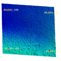
A joint work plan has been designed for the establishment of long-term 1-hectare plots and their inventory in the Shimoga Division of North Karnataka for the Validation of NISAR forest biomass products. The participants for this Joint Work Plan are Space Application Center, ISRO, Ahmedabad, College of Forestry, Dharwad; and Kerala University of Fisheries & Ocean Studies (KUFOS).
NISAR will also provide forest volume and biomass over time and with enough detail to reveal changes on human scales. Products are expected to be available 1-2 days after observation, and within hours in response to disasters, providing actionable, timely data for many applications.
Determining appropriate forest parameters
Appropriate forest parameters are crucially related to forest inventory. Traditionally, parameters such as diameter and total height are measured in the arena by level gauges and hypsometers. However, field inventories are usually established on sample plots, which, irrespective of providing valuable and necessary data, are laborious, expensive, and spatially limited.
The majority of the work developed for remote measurement features makes use of terrestrial laser scanning (TLS), which has a high density of clouds, which is advantageous for accurate forest inventory.
However, TLS also continues to have a spatial limit to its application because it needs to be manually carried to succeed in the market, which necessitates sometimes difficult field access and frequent requirement of field crew.
Airborne LiDAR survey for inventory mapping
When compared to aircraft-borne programs, drone-based LiDAR has a much higher likelihood of measuring the parameters and providing much higher occurrence point cloud data. This project utilizes drone LiDAR system to measure an individual’s considerable tree height and girth while working with an automated and integrated approach.
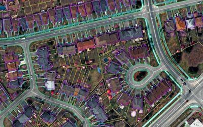
The project maps forest canopies, tree heights, and tree girth using innovative geospatial technologies, which includes drone-based LiDAR survey. The associated products are DSM (digital surface model), DTM (digital terrain model), and ortho-rectified imagery (ORI).
The project used an industry-standard drone to acquire the LiDAR and RGB imagery. To improve the accuracy and quality of the data, the ground control points (GCPs) were collected from the ground using DGPS.
Extraction of forest resources such as canopy height, forest cover, girth of the trees and tree count was carried out using LAS tools, .bat scripts, Terrasolid tools, ArcGIS MAP tools, and Global Mapper tools.
Aside from the foremost tools, Python software was also used to run the programs, particularly the.bat scripts. The tools greatly helped to automate the process to a certain extent. On occasions, height and girth of the tree were also measured manually to improve the quality and meet the standards.
LiDAR data processing
Derivatives processing: Processing of derivatives was carried out in batches using LiDAR and imagery. GCP import and AOI preparation in Microstation were the first steps in the process. All received drone survey coordinates were imported into the Microstation and the collection of GCP locations was performed. AOI boundary was created by connecting all imported GCPs
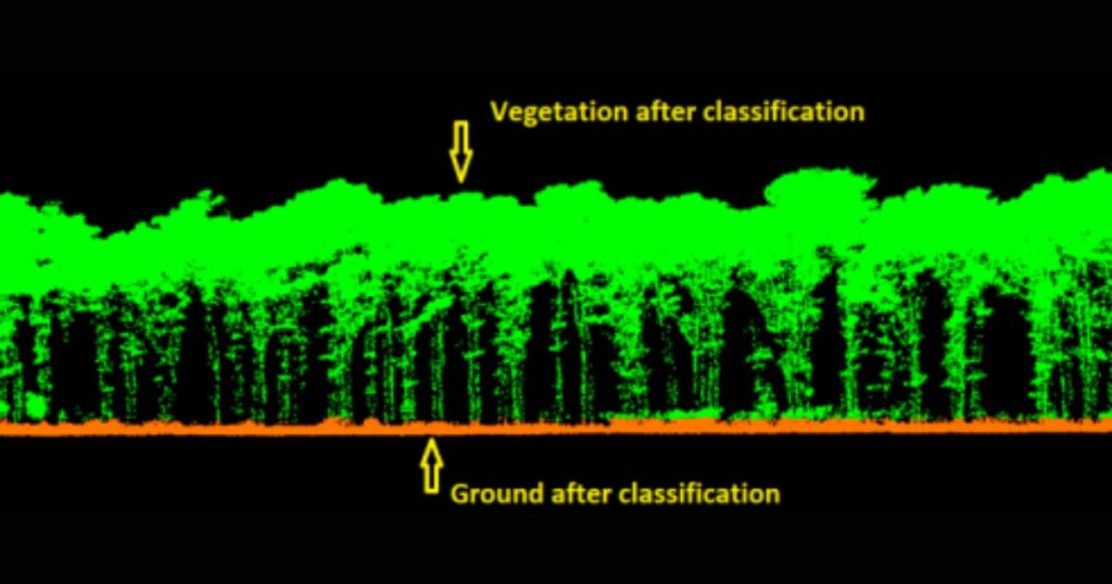
Laz data import and classification: In this process, raw laz data was classified into different classes as per ASPRS standard Lidar point classes. Vegetation and ground were classified by the ground team. The programmers developed the tree measurement tools for the automation of the flow of work. The Laz data density was 600 ppm to 1300 ppm.
ORI Generation (Ortho rectified imagery): The project team generated ORI in DJI terra by using RGB imagery. The imagery was rectified using DTM generated from the Laz data. Spatial accuracy was checked by verifying ORI with the GCPs. The ORIs have been generated with a resolution of 2 cm.

Ortho rectified imagery (ORI) and ORI with Laz data
DTM and DSM generation and geo-Tiff conversion: To generate DSM and DTM, classified Laz data was used as input. For DTM generation, ground Laz was used and for DSM, all the Laz data was used. Spikes were removed from the point clouds for DSM generation. DSM and DTM were converted into GeoTiff formats for uniform scale. This process helped create the final deliverables DTM and DSM with 2-pixel resolution.
DSM with GCP overlay
DTM with GCP overlay
Tree top, bottom, and girth Identification: This process was undertaken for the trees that are within the AOI. By using the section option in Micro Station, the team placed the top and bottom points. By using the measuring tool, the team calculated the girth and tree height. The automation process gives the tree numbers and x, y coordinates for trees.
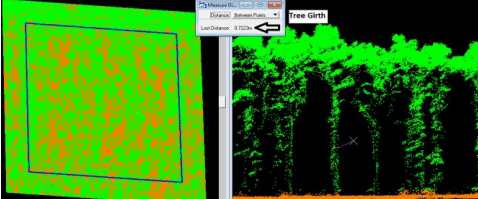
Finding tree girth
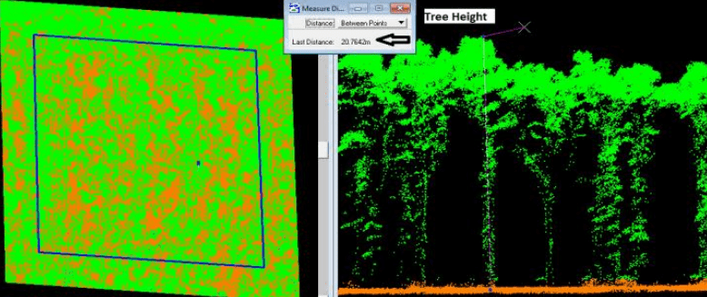
Finding tree height
Based on the vegetation measurements, the report was prepared as required. QC report for deliverables was generated after checking all the deliverables.
The drone LiDAR survey advantage
The use of drone-based LiDAR in the project helped generate DTM (digital terrain model) and DSM (digital surface model) with a 2-pixel resolution, a very high accuracy data that helped the project meet its objective of actionable, timely data for many applications for sustainable development based on forest information.