SVAMITVA, the national project of the Government of India for “Record of Rights” for rural household owners, is deploying drone mapping to create accurate property records and GIS maps for development plans
The SVAMITVA (Survey of Villages and Mapping with Improvised Technology in Village Areas) project is an initiative launched by the Indian government to provide property rights to rural households in India. The aim of the project is to survey and digitize the records of rural properties and provide property ownership certificates to rural households. This will help improve transparency in rural property transactions and enhance the rural economy. The project is expected to benefit over 250 million rural households and is considered a major step towards modernizing India’s rural property market.
Addressing lack of recognition and documentation of rural property holdings in India
The concept of property rights in India has been predominantly centered around urban areas, leaving rural households with little recognition or documentation of their property holdings. This has resulted in numerous issues such as disputes over property ownership, lack of access to credit, and difficulty in selling or transferring property. The SVAMITVA project was launched to address these issues and provide a comprehensive solution for rural property rights.
The project involves mapping rural properties using Drone imagery and other technological tools. The surveyed data is then digitized and stored in a centralized database, which is accessible to the relevant authorities and the rural households. This process will provide rural households with legally recognized ownership certificates, which they can use for various purposes such as availing credit, selling or transferring property, and resolving disputes.
The SVAMITVA project is significant because it represents a shift towards modernizing India’s rural property market. The project is expected to provide a boost to the rural economy by increasing transparency and reducing disputes over property ownership. It is also expected to provide a more accurate representation of rural property holdings, which will enable the government to make better policy decisions for rural development.
The problem that the SVAMITVA project addresses is the lack of recognition and documentation of rural property holdings in India. Despite the significance of property ownership in a person’s life, rural households in India have limited access to property rights and ownership certificates. This has resulted in several problems such as:
- Disputes over property ownership: Lack of proper documentation and recognition of property ownership has led to numerous disputes among rural households.
- Inadequate access to credit: Without proper documentation of property ownership, rural households are unable to use their property as collateral for availing credit.
- Difficulty in selling or transferring property: Lack of proper documentation makes it challenging for rural households to sell or transfer their property
- Inaccurate representation of rural property holdings: The absence of proper documentation and records makes it difficult for the government to get an accurate representation of rural property holdings and make informed policy decisions.
Mapping rural property holdings to create accurate property records
The objective of the SVAMITVA project is to survey and map rural property holdings in India, with the aim of creating a centralized database of rural property holdings and issuing property ownership certificates to rural property owners.
The project aims to enhance rural property transactions by providing rural property owners with a recognized proof of ownership and increase transparency in rural property transactions by having accurate property records. The project also aims to provide the government with updated information on rural properties to aid in policy making and planning.
The scheme aims to:
- Update /create property records
- Provide an opportunity for dispute resolution
- Help villagers capitalize residential property
- Update property and asset register to strengthen tax collection and demand assessment process of gram panchayats in states where property tax is devolved to the gram panchayats.
The spatial data captured under this programme would also support the preparation of better-quality Gram Panchayat Development Plans (GPDPs) to help in the development and execution of planning activities.
The scheme is a collaboration of the Ministry of Panchayati Raj, state Panchayati Raj departments, state Revenue departments.
Drone surveying and data validation
The SVAMITVA Scheme has identified the need for drone technology, along with CORS (Continuously Operating Reference Station), for capturing images in a time- transparent and cost-effective manner to generate high-resolution, accurate maps that would be used to create durable records of property holdings and generate property cards.
Survey of India (SoI), the national mapping agency of India, is the implementation technology partner for the scheme. SOI is responsible for acquisition of images, procurement of drones, feature/ asset identification, and ground truthing and validation of land parcels, in collaboration with relevant departments.
- Mapping of rural properties using Drone imagery and other technological tools
Marvel Geospatial, a leader in drone mapping technology, has been selected by the highly esteemed Survey of India (SOI) to undertake the ambitious SVAMITVA project. This initiative aims to precisely survey the rural property holdings in India, leveraging the latest in drone mapping technology.
Marvel Geospatial’ s unparalleled proficiency in drone mapping and its formal appointment by the SOI make it an ideal candidate for this significant endeavour. The company’s innovative drone mapping methodology, which encompasses the acquisition of high-resolution images of the land and property holdings, is supplemented by the SOI’s chuna (limestone) marking procedure, in which rural property boundaries are meticulously demarcated on the ground.
This harmonious integration of drone mapping technology and chuna marking guarantees the veracity and legitimacy of the data collected during the mapping process. The information gathered by Marvel Geospatial will be utilized by the relevant authorities to grant property ownership certificates and establish a centralized database of rural property holdings in India
In Gujarat and Karnataka, two of its empanelled states, Marvel Geospatial is undertaking drone mapping of the identified areas. The data captured through drones is processed to create ortho-rectified images (ORI).

Drone flying gets under way
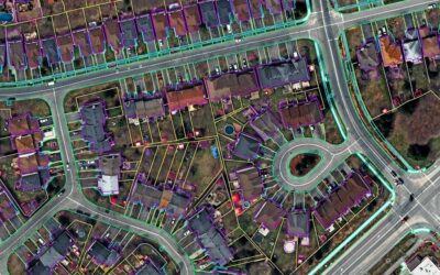
The ORI is used by Survey of India for extraction of topographical features including property boundaries that are marked on ground jointly by gram panchayats and state revenue departments. Attribute information and other secondary information is incorporated into a GIS database. Further, land parcel map of 1:500 scale is generated, numbering of properties/structures within the identified area is done as per the numbering system provided by the State Revenue Department. The ORI and digital maps are validated and verified on-ground by Survey of India and state revenue department for accuracy.
- Digitization of property records
The collected data will be stored in a digitized format in a centralized database, which will be accessible to the relevant authorities and the rural households.
- Verification of property ownership
The ownership details collected during the mapping process will be verified through a door-to-door verification process.
Data validation and quality control: The data collected and digitized will be subjected to regular quality control and validation processes to ensure accuracy and integrity.

Drone data being processed
Post validation and verification, final land parcel maps (LPMs), village maps /digital GIS maps and GIS databases are created. Final deliverables, including final maps and GIS database, are handed over by Survey of India to state revenue departments and state rural development/ Panchayati Raj departments.
- Issuance of property ownership certificates
Upon successful verification of ownership details, property ownership certificates will be issued to the rural households.
Benefits of drone mapping for SVAMITVA project
Drones are thus playing a critical role in successful implementation of the SVAMITVA scheme and achieving its desired objectives through:
- Reduced errors/higher accuracy in drawing property boundaries due to high accuracy data generated from drones
- Survey of villages in remote or difficult terrain areas
- Fast and reliable data collection enabling Pan-India coverage in a short period of time
- Generation of highly accurate GIS maps of villages from drone data that can be used for planning, development and welfare activities of various departments.
Reference: Svamitva.nic.in